|
There will be a Smithneck Road Closure this week for paving. Local traffic will be able to access their homes, all others will need to take the detour through Sierra Brooks.
Even though other local organizations have had to cancel their events, The Sierra Schools Foundation has announced it will again hold its annual Swinging for the Schools Golf Tournament fundraiser Oct. 3 at Plumas Pines Golf Course. Registration is only online this year: https://www.sierraschoolsfoundation.org/golf and includes greens fees, a cart, custom masks, golf awards and prizes, and a coupon for food at the course. The tournament will be a scramble format, with awards for team scores and individual feats. SSF founder Megan Meschery said, “This is our only fundraiser, and we have sincerely appreciated the support we have received over many years from individuals and businesses who have helped us raise funds for the school children of the Sierra-Plumas schools. “Restrictions related to COVID-19 have changed up a lot of what we can offer this year, but we are hoping that past and new supporters will appreciate our offering a fun opportunity to play golf with friends and family and give as they have in the past to help the good work of the foundation. The needs are even greater in this season, so we are trying to do more. We just hope our golfers, donors, and sponsors can help us do that.” The Sierra Schools Foundation has stepped up to help the schools in many ways in the last year. These are just a few grant projects SSF funded:
More information about SSF and the tournament is available from Megan Meschery at (530) 414-3655. Sparks, NV, August 31, 2019 – According to the Feeding America study, The Impact of the Coronavirus on Local Food Security, Nevada is likely to be one of the hardest hit states as it relates to food insecurity. They are projecting that Nevada’s food insecurity will rise to 20% in 2020 (up from 12.8%) Feeding America is also predicting that Nevada will be in the top 3 states for the highest rate of child food insecurity in the nation, at 32.9%, which are more than 226,500 children.
In the face of these daunting statistics, the Food Bank of Northern Nevada is asking supporters in all of the far reaches of their 90,000 square mile service area to join together to fight hunger in their community. September is Hunger Action Month, a national campaign with Feeding America and more than 200 network food Banks like the Food Bank of Northern Nevada. The awareness campaign is designed to mobilize the public around the issue of hunger. The Food Bank of Northern Nevada has designed many activities with a virtual twist like a virtual Hunger Action Month Bingo game where participants take part in their own hunger fighting activities until they receive a “Bingo” on the card. Each person who reaches this milestone will receive and entry in a free drawing for some great prizes including Hello Fresh meals, dinner certificates, games and desserts you can take to your own place. Details on the Bingo card and how to play are listed here. Thursday, September 10 is designated as Hunger Action Day and participants are asked to wear orange and post on social media about why they are doing it, to raise awareness for the many people in Nevada who face hunger every day. The Food Bank of Northern Nevada reminds participants to tag the Food Bank @Foodbanknn and use the hashtags #ifighthunger and #hungeractionmonth. New this year, Hunger Action Month marks the launch of a special campaign designed to show that small donations make big differences when you are fighting hunger. The campaign is Portraits for Produce and the goal is to secure 340,000 lbs. of fresh nutritious produce with 2,020 people donating $20 each. For joining the campaign, supporters will receive a fun personalized keepsake portrait. The public is invited to join the campaign by clicking here. Again, this September, the Run on Tuna returns for its 10th year where De De and Michelle, the tuna warriors will set out to gather 10,000 cans of tuna. More details on how to get involved are at fbnn.org/ham. The Food Bank is also recruiting volunteers in September and beyond. The shifts are smaller to allow for social distancing but the work is significant in the warehouse, at distributions, and even for occasional office work. The situation changes quickly so volunteers are asked to check frequently to see what opportunities are open. Volunteers can check for available volunteer opportunities at fbnn.org/volunteer. On Thursday, September 24 they will be holding another FeedNV Drive through Food Drive at Nevada State Bank at 500 E. Prater Way in Sparks. Donors will be able to drop donations in a safe and touchless way with volunteers unloading them from the car or trunk. The drive will be from 9 a.m. – noon and some of the rural communities served by the Food Bank will also be participating through the partner agencies in those communities. A full list will be at fbnn.org/ham. Hunger Action Month also includes an opportunity to advocate to elected officials about hunger. The Food Bank advocates for our elected officials to come together to lift up struggling families in need of food assistance. There are two issues that Feeding America and other hunger relief advocates are working on right now. Write or call your Member of Congress to show your support for these measures:
### A two-part strategy to finance vital Emergency Medical Services (EMS) in western Sierra County will appear on the November 3, 2020 ballot in the form of tax measures. On voter approval, the measures will establish sustainable funding for advanced EMS, Fire & Rescue Services. Currently, there is no public support for EMS care in Sierra Country. Ballot Measure E provides that visitors will pay a portion of the EMS costs provided by the Fire Districts.
Ambulance service in Sierra Valley is provided by paramedic-staffed ambulances from Eastern Plumas Healthcare. Ambulance service in western Sierra County is provided by Downieville Fire Protection District staffed by volunteers and a paramedic paid for by private donations. The current Downieville Fire Protection District advanced EMS budget is $100,000 and includes donated financial support for the paramedic, advanced medications, equipment, and supplies. Downieville ambulance is the local lifeline, delivering emergency care for both the Sierra City Fire District and the Downieville Fire Protection District. Ballot Measures G & H offer a blended approach to fund Advanced EMS and Fire & Rescue Services by dividing the responsibility between property owners and visitors. This concept consists of an affordable property tax measure and a slight increase in the Transient Occupancy Tax (TOT). The TOT rate is currently 10%, and it is paid by visitors that rent motel rooms, vacation houses, inns, and resorts. None of the measures are tied together, so they can each pass independently. The specifics of the measures are as follows: MEASURE E: INCREASED TRANSIENT OCCUPANCY TAX (TOT) FOR VISITOR SUPPORTED COUNTYWIDE EMS, FIRE AND RESCUE CARE · Will increase the TOT paid by overnight visitors by 2.5% · TOT increase will support EMS & Fire & Rescue ONLY · E will raise about $19,500 annually for Downieville Fire Protection District (DFPD) · E will raise about $33,500 annually for Sierra City Fire District (SCFD) · E will raise about $26,000 annually for Sierra County Fire District #1 · Will start July 1, 2021 · 2/3 approval required by all registered voters in Sierra County MEASURES G & H: DOWNIEVILLE & SIERRA CITY PROPERTY TAX FOR ADVANCED LIFE SUPPORT EMS, FIRE & RESCUE SERVICES
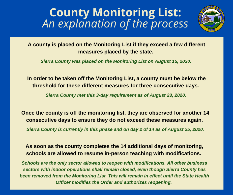
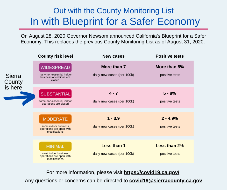
What does this mean for Sierra County businesses? How can you help move Sierra County forward in the Tiers?
replaces the previous County Monitoring List process as of August 31, 2020. In the new model, Sierra County is considered to be in the Substantial Spread Red Tier 2. Visit California Department of Public Health (CDPH) to understand county categorization and the process for moving from one tier to another. This change effects the following sectors which are now allowed to conduct activities in-doors; Restaurants (25% capacity), Churches (25% capacity), Barbers and Salons. If a Memorandum of Understanding (MOU) has already been approved by Sierra County Public Health, nothing else is needed. Current Industry Guidance is linked on the redesigned COVID19.CA.GOV website. Each sector is responsible for insuring they are adhering to the latest guidance. The State Health Officer order has been up-dated, taking effect on August 31st, to include the new tiers and re As of Sunday morning, nearly 16,000 firefighters continue to battle nearly two dozen major fires and lightning complexes across California. Firefighters continue to make good progress on a number of fronts, as reflected in the increased containment figures on all of the fires. As progress is made, many of the evacuation orders have been lifted or downgraded. However, over 60,000 people remain evacuated from the current wildfires. Since the lightning siege that started on Saturday, August 15, 2020, there have been nearly 14,000 lightning strikes. During this time-period, there have been more than 840 new wildfires, which have now burned over 1.42 million acres. The significant acreage burned makes the fires collectively larger than the State of Delaware. In this siege, there have been seven reported fatalities and nearly 2,500 structures destroyed. Seasonable weather conditions continue to aid firefighters in their efforts towards containment at lower elevations. Above 2,000 feet firefighters are still seeing low humidity without recovery at night. Warmer conditions are expected over the weekend and Isolated thunderstorms are still possible in the upper portion of northern California and the Sierra Nevada Mountain Range. A Fire Weather Watch has been upgraded to a Red Flag Warning for interior Del Norte County, and Northeast Humboldt counties due to gusty winds and poor humidity recovery. Californians need to take steps to prevent sparking a wildfire. To learn more ways to prevent sparking a wildfire visit www.ReadyForWildfire.org. Fires of Interest: **CAL FIRE Incidents** LNU Lightning Complex Fire, Napa County (more info…) Napa, Lake, Sonoma, Solano, and Yolo Counties State DPA, SRA, Napa County *375,209 acres, 56% contained *Hennessey (merged fires) 317,909 acres, 56% contained *Wallbridge 54,940 acres, 55% contained *Meyers 2,360 acres, 99% contained *1,198 structures destroyed *Evacuations in place *CAL FIRE IMT-2 in command SCU Lightning Complex Fire, Contra Costa, Alameda, Santa Clara and Stanislaus Counties (more info…) Contra Costa, Alameda, Santa Clara and Stanislaus Counties *377,471 acres, 50% contained *20 fires in the complex, several have merged together *Canyon/Reservoir (merged) 374,367 acres 50% contained *Deer 3,104 acres 100% contained *Evacuations and road closures in place *53 structures destroyed * CAL FIRE IMT-6 in command CZU August Lightning Fire, San Mateo and Santa Cruz Counties (more info…) San Mateo and Santa Cruz Counties *84,640 acres, 35% contained *Warnell Fire has now merged into CZU Lightning *Evacuations in place *1,177 structures destroyed *CAL FIRE IMT-3 is in command BTU/TGU Lightning Complex Fire, Butte and Glenn Counties (more info…) Butte, Tehama and Glenn Counties *58,6546 acres, 39% contained *Elkhorn 39,045 acres, 37% contained *Ivory/Doe 16,100 acres, 85% contained *Potters (5-4) 927 acres, 97% contained *CAL FIRE IMT-4 in command River Fire, Monterey County (more info…) East of Salinas *48,088 acres, 87% contained *30 structures destroyed *Repopulation is complete *CAL FIRE IMT-1 in command Carmel Fire, Monterey County (more info…) South of Carmel *6,905 acres, 89% contained *73 structures destroyed *Repopulation is complete *CAL FIRE IMT 1 Team in command Moc Fire, Tuolumne County (more info…) Moccasin *2,800 acres, 98% contained **Federal Incidents** Lake Fire, Los Angeles County (more info…) Southwest of Lake Hughes * 31,089 acres, 87% contained *Structures threatened August Complex, Tehama County (more info…) Grindstone Canyon, Elk Creek *221,284 acres 18% contained *Includes the Hull Fire and Doe Fire Dolan Fire, Monterey County (more info…) Ventana Wilderness – Los Padres National Forest * 25,587 acres, 25% contained Ranch 2 Fire, Los Angeles County (more info…) FINAL San Gabriel Canyon *4,237 acres, 96% contained Apple Fire, Riverside County (more info…) Cherry Valley *33,424 acres, 95% contained North Complex Fire, Plumas County (more info…) Southwest of Susanville - Plumas National Forest * 57,479 acres, 37% contained *Evacuations in place *Includes the Sheep and Claremont Fire *CA IMT Team 1 is in command Loyalton, Vegetation Fire, Sierra County (more info…) East of Loyalton – Tahoe National Forest *47,029 acres, 93% contained Red Salmon Complex – Shasta-Trinity National Forest (more info…) Northeast of Willow Creek, CA *23,221 acres, 42% contained SQF Complex, Tulare County (more info…) East of Giant Sequoia National Monument/ Golden Trout Wilderness *34,283 acres, 0% contained *Castle and Shotgun Fires merged into this complex W-5 Cold Springs, Lassen County (more info…) East of Madeline. *74,819 acres, 53% containment Dome, San Bernardino County (more info…) Mojave National Preserve *43,273 acres, 95% contained Beach, Inyo County (more info…) FINAL Inyo National Forest *3,780 acres, 100% contained Blue Jay/Wolf Fire, Mariposa County (more info…) Yosemite National Forest *806 acres, 15% contained Woodward Fire, Marin County (more info…) Point Reyes National Seashore *3,269 acres 15% contained Trimmer Fire, Fresno County FINAL Sierra National Forest *600 acres, 99% contained **Contract County** Johnson, Vegetation Fire, Los Angeles County (more info) East of Elizabeth Lake 290 acres, grass and brush, 97% contained More than 15,800 firefighters today are continuing to work towards containment on over two dozen major fires and lightning complexes, all while responding to hundreds of new emergencies and wildfires each day. In the past 24-hours there were over 10 lightning strikes in California, yet only one small fire was reported. A warming trend is likely over the next few days, with low humidity. Damage inspection teams continue to perform a thorough assessment of the fire areas. Since the lightning siege that started on Saturday, August 15, 2020, there have been nearly 14,000 lightning strikes. During this time-period, there have been more than 800 new wildfires, which have now burned over 1.4 million acres. In this siege, there have been 7 reported fatalities and over 2,200 structures destroyed. Warm and dry conditions continue today, with periods of weak North to Northeast winds possible this afternoon in Northern California. A Fire Weather Watch has been issued by the National Weather Service in Del Norte and Siskiyou counties for Sunday afternoon to Monday morning for north winds and low humidity. Beginning Sunday, a warming trend will lead to very hot and dry weather by the middle of next week. CAL FIRE continues to urge all Californians to take steps to prevent sparking a wildfire. To learn more ways to prevent sparking a wildfire visit www.ReadyForWildfire.org. Fires of Interest: **CAL FIRE Incidents** LNU Lightning Complex Fire, Napa County (more info…) Napa, Lake, Sonoma, Solano, and Yolo Counties State DPA, SRA, Napa County *373,324 acres, 41% contained *Hennessey (merged fires) 315,611 acres, 39% contained *Wallbridge 55,353 acres, 42% contained *Meyers 2,360 acres, 99% contained *1,119 structures destroyed *Evacuations in place *CAL FIRE IMT-2 in command SCU Lightning Complex Fire, Contra Costa, Alameda, Santa Clara and Stanislaus Counties (more info…) Contra Costa, Alameda, Santa Clara and Stanislaus Counties *374,471 acres, 40% contained *20 fires in the complex, several have merged together *Canyon/Reservoir (merged) 371,367 acres 40% contained *Deer 3,104 acres 100% contained *Evacuations and road closures in place *53 structures destroyed * CAL FIRE IMT-6 in command CZU August Lightning Fire, San Mateo and Santa Cruz Counties (more info…) San Mateo and Santa Cruz Counties *83,335 acres, 29% contained *Warnell Fire has now merged into CZU Lightning *Evacuations in place *899 structures destroyed *CAL FIRE IMT-3 is in command BTU/TGU Lightning Complex Fire, Butte and Glenn Counties (more info…) Butte, Tehama and Glenn Counties *57,359 acres, 33% contained *Elkhorn 37,750 acres, 33% contained *Ivory/Doe 16,100 acres, 60% contained *Potters (5-4) 927 acres, 97% contained *CAL FIRE IMT-4 in command River Fire, Monterey County (more info…) East of Salinas *48,732 acres, 76% contained *30 structures destroyed *Repopulation is complete *CAL FIRE IMT-1 in command Carmel Fire, Monterey County (more info…) South of Carmel *6,767 acres, 81% contained *73 structures destroyed *Repopulation is complete *CAL FIRE IMT 1 Team in command Moc Fire, Tuolumne County (more info…) Moccasin *2,800 acres, 98% contained Jones Fire, Nevada County (more info…) FINAL Northwest of Nevada City *705 acres, 100% contained *21 residential structures destroyed **Federal Incidents** Lake Fire, Los Angeles County (more info…) Southwest of Lake Hughes * 31,089 acres, 82% contained *Continued structure threat August Complex, Tehama County (more info…) Grindstone Canyon, Elk Creek *215,558 acres 18% contained *Includes the Hull Fire and Doe Fire Dolan Fire, Monterey County (more info…) Ventana Wilderness – Los Padres National Forest * 25,587 acres, 20% contained Ranch 2 Fire, Los Angeles County (more info…) San Gabriel Canyon *4,237 acres, 96% contained *Road closures lifted *Federal Type 2 in command Apple Fire, Riverside County (more info…) Cherry Valley *33,424 acres, 95% contained North Complex Fire, Plumas County (more info…) Southwest of Susanville - Plumas National Forest * 57,406 acres, 25% contained *Evacuations in place *Includes the Sheep and Claremont Fire *CA IMT Team 1 is in command Loyalton, Vegetation Fire, Sierra County (more info…) East of Loyalton – Tahoe National Forest *47,029 acres, 93% contained Red Salmon Complex – Shasta-Trinity National Forest (more info…) Northeast of Willow Creek, CA *21,980 acres, 42% contained SQF Complex, Tulare County (more info…) East of Giant Sequoia National Monument/ Golden Trout Wilderness *25,891 acres, 0% contained *Castle and Shotgun Fires merged into this complex W-5 Cold Springs, Lassen County (more info…) East of Madeline. *72,196 acres, 45% containment Dome, San Bernardino County (more info…) Mojave National Preserve *43,273 acres, 95% contained Beach, Inyo County (more info…) Inyo National Forest *3,780 acres, 90% contained Blue Jay/Wolf Fire, Mariposa County (more info…) Yosemite National Forest *679 acres, 15% contained Woodward Fire, Marin County (more info…) Point Reyes National Seashore *3,072 acres 10% contained Spring Fire, Shasta County FINAL Shasta-Trinity National Forest *230 acres, 100% contained Trimmer Fire, Fresno County Sierra National Forest *600 acres, 99% contained R-8 Pinecone, Lassen County (more info…) FINAL West of Termo *567 acres, 100% contained **Contract County Incidents** Johnson, Vegetation Fire, Los Angeles County Johnson Rd x Limeridge Dr, East of Elizabeth Lake *290 acres, grass and brush, 80% contained ### Plumas NF Claremont and Bear Fires Closure -Temporary closure to protect firefighters and public-8/29/2020 QUINCY, Calif. – Plumas National Forest officials have enacted a temporary closure order through October 31, 2020, for national forest land, roads and trails within the Claremont and Bear Fires area. The closure is in place 24-hours/day due to the unsafe conditions. “We can’t overstate the dangerous conditions, seen and unseen, that exist in and around the fire areas,” said Chris Carlton, Forest Supervisor. He noted it will take some time to secure a perimeter around the fires and get it sufficiently mopped-up to preclude the fires from moving. Those exempt from the order include: 1) any Federal, State or local officer, or member of an organized rescue or fire fighting force in the performance of an official duty; 2) persons with Forest Service Permit No. FS-7700-48 (Permit for Use of Roads, Trails, or Areas Restricted by Regulation or Order), specifically exempting them from this Order; 3) owners or lessees of land in the Claremont and Bear Fires Closure Area, to the extent necessary to access their land; and, 4) Persons with a permit from the Forest Service specifically authorizing the otherwise prohibited acts or omission. A map of the closure area is available at: https://www.fs.usda.gov/alerts/plumas/alerts-notices For more information about the Claremont and Bear Fires, see, respectively, https://inciweb.nwcg.gov/incident/6996 and https://inciweb.nwcg.gov/incident/7025/ , call North Complex Fire Information at (530) 316-4487, and visit https://www.Facebook.com/usfsplumas . A similar closure is in place for the Sheep Fire area https://inciweb.nwcg.gov/incident/7067/ . ### Twitter: @usfsplumas Plumas NF Claremont and Bear Fires Closure -Temporary closure to protect firefighters and public- USDA is an equal opportunity provider, employer, and lender. -Permits remain free through September 30, 2020- QUINCY, Calif. – While personal use fuelwood (firewood) permits will remain free through September 30, 2020, effective September 9, you will be required to hold a Plumas National Forest (PNF) “hard copy” personal fuelwood permit (includes tags) and follow the associated regulations within that permit. “While our offices remain physically closed, we are committed to providing services on our public lands and doing what we can to help those in need,” said Chris Carlton, Forest Supervisor. “You may request your free personal fuelwood permit by email or phone until September 30, 2020, and we will mail your permit with regulations, woodcutting area map, and tags.”
These permits are only valid on Plumas National Forest lands open to fuelwood gathering. You can obtain permits for up to 12 cords of firewood for personal use per year. A cord is the amount of tightly piled wood in a stack four feet high by four feet wide by eight feet long. Firewood permits obtained this year may be used through the end of December 2020. As a reminder, commercial fuelwood is not part of the free permit program, and commercial permits must be purchased. Commercial-use fuel/firewood permits and tags are required when the fuel/firewood collector (cutter) intends to sell, trade or exchange fuel/firewood. -more- USDA is an equal opportunity provider, employer, and lender. Reno Discussion:
KEY POINTS · Smoke: Widespread haze from smoke likely to persist the rest of this week. Ozone can also contribute to lower visibility. Areas of denser smoke likely across NE California into parts of W Nevada from fires in N California. · T-Storm Trends: Moisture never quite leaves the area, so at least garden variety isolated storms each day through Friday mainly over high terrain and in NE California east of Lassen Peak. Today coverage could be a little more for NE California and simulations also showing storms along the Sierra Front east of Reno, Carson City. Typical impacts expected: outflow winds, lightning and new fire starts, spots of heavy rain, small hail. · Maybe Cooler, More Wind? Signs of increased winds with cooler temps late this weekend into early next week. 1 in 2 simulations show breezy afternoon winds either Sunday or Monday, with Monday the leading contender. Could result in critical fire weather conditions. Not a lock yet - still a bit of variability in simulations. CHANGES FROM PREVIOUS BRIEFING · Slightly better chances for t-storms today NE California and Sierra Front east of Reno, Carson City. · Gradually increased confidence in seeing breezy/low-rh scenario early next week. Exemptions Needed for Temporary Signs Visible From Highway
MARYSVILLE – With the 2020 general election season gearing up, political candidates and campaign workers for either an office or a ballot measure are reminded about a state law governing the placement of “Temporary Political Signs” within view of a state highway. Section 5405.3 of the State Outdoor Advertising Act allows an exemption for the placement of “Temporary Political Signs” along certain state highways. However, these signs are not to be placed within the state right of way. In addition, signs cannot be visible within 660 feet from the edge of the right of way of a classified “landscaped freeway.” In Caltrans District 3, there are 76 miles of roadway in the 11-county Sacramento Valley and Sierra Region that fall under the “landscaped freeway” classification, which covers ornamental planting covering at least a 1,000-foot-long continuous stretch of state right of way. (See attached list of landscaped freeways) If campaign signs are within view of a state highway, candidates MUST file a Statement of Responsibility form with Caltrans’ Outdoor Advertising Program in Sacramento. A temporary political sign meets the following criteria:
State law directs Caltrans to remove unauthorized temporary political signs and bill the responsible party for their removal. For more information or copy of the form “Statement of Responsibility” for temporary political signs, please visit: https://dot.ca.gov/programs/traffic-operations/oda/political-signs Continued favorable weather conditions continue to aid firefighters in their efforts towards containment. More than 15,000 firefighters today are battling over two dozen major fires and lightning complexes across California. In the past 24-hours there were over 400 lightning strikes in Northern California. Firefighters continue to monitor for additional lightning strike wildfires. As firefighters continue to make good progress towards containment on all the fires, and thanks to the efforts of firefighters two fires have been fully contained. Since the lightning siege that started on Saturday, August 15, 2020, there have been nearly 14,000 lightning strikes. During this time-period, there have been more than 700 new wildfires, which have now burned over 1.32 million acres. The significant acreage burned makes the fires collectively larger than the State of Delaware. In this siege, there have been 7 reported fatalities and nearly 1,700 structures destroyed. California firefighters continue to get assistance from other states and the military. 91 fire engines from nine western states are assigned to incidents. The California National Guard has been providing assistance in battling the wildfires with aircraft and guard members. Their activation includes 17 water dropping helicopters, 4 C-130 aircraft, and over 1,800 personnel. Weather conditions continue to improve compared to last week. A strong marine layer has returned, which has helped raise relative humidity and lower temperatures in some areas. However, with a strong marine layer comes a strong onshore flow especially in the afternoon. Gusty winds can be expected of 15-20mph. This can make firefighting conditions challenging during those times for the next couple days. Warmer conditions are expected over the weekend. Isolated thunderstorms are still possible in the upper portion of northern California and the Sierra Nevada Mountain Range. The rest of California will experience a return to a warm and dry weather pattern. Californians need to take steps to prevent sparking a wildfire. To learn more ways to prevent sparking a wildfire visit www.ReadyForWildfire.org. Fires of Interest: **CAL FIRE Incidents** LNU Lightning Complex Fire, Napa County (more info…) Napa, Lake, Sonoma, Solano, and Yolo Counties State DPA, SRA, Napa County *357,046 acres, 33% contained *Hennessey (merged fires) 299,763 acres, 33% contained *Wallbridge 54,923 acres, 19% contained *Meyers 2,360 acres, 97% contained *978 structures destroyed *Evacuations in place *CAL FIRE IMT-2 in command SCU Lightning Complex Fire, Contra Costa, Alameda, Santa Clara and Stanislaus Counties (more info…) Contra Costa, Alameda, Santa Clara and Stanislaus Counties *365,772 acres, 25% contained *20 fires in the complex, several have merged together *Canyon/Reservoir (merged) 360,668 acres 15% contained *Deer 3,104 acres 100% contained *Evacuations and road closures in place *20 structures destroyed *CA IMT-6 in command CZU August Lightning Fire, San Mateo and Santa Cruz Counties (more info…) San Mateo and Santa Cruz Counties *80,137 acres, 19% contained *Warnell Fire has now merged into CZU Lightning *Evacuations in place *538 structures destroyed *CAL FIRE IMT #3 is in command BTU/TGU Lightning Complex Fire, Butte and Glenn Counties (more info…) Butte, Tehama and Glenn Counties *53,684 acres, 27% contained *Elkhorn 35,000 acres, 25% contained *Ivory/Doe 15,800 acres, 18% contained *Potters (5-4) 927 acres, 95% contained *CAL FIRE IMT- 4 in command River Fire, Monterey County (more info…) East of Salinas *48,424 acres, 48% contained *12 structures destroyed *Evacuations in place *CAL FIRE IMT Team 1 in command Carmel Fire, Monterey County (more info…) South of Carmel *6,695 acres, 45% contained *73 structures destroyed *Evacuations in place *CAL FIRE IMT 1 Team in command Moc Fire, Tuolumne County (more…) Moccasin • 2,800 acres, 60% contained • Continued structure threat • Evacuations in place Salt Fire, Calaveras County (more info…) FINAL Northeast of Copperopolis *1,789 acres, 100% contained Hills Fire, Fresno County (more info…) FINAL South of Coalinga *2,121 acres 100% contained Jones Fire, Nevada County (more info…) Northwest of Nevada City *705 acres, 85% contained *Evacuations in place *21 residential structures destroyed **Unified Command Fires** Lake Fire, Los Angeles County (more info…) Southwest of Lake Hughes * 31,089 acres, 70% contained *Continued structure threat *Unified Command USFS and Los Angeles County Fire *CA IMT Team 5 is in command **Federal Incidents** Sheep Fire, Plumas County (more…) Southwest of Susanville * 28,903 acres 3% contained August Complex, Tehama County (more…) Grindstone Canyon, Elk Creek *197,148 acres 17% contained *Includes the Hull Fire and Doe Fire Dolan Fire, Monterey County (more info…) Ventana Wilderness – Los Padres National Forest * 20,397 acres, 15% contained Ranch 2 Fire, Los Angeles County (more info…) San Gabriel Canyon *4,237 acres, 96% contained *Road closures in place *Federal Type 2 in command Apple Fire, Riverside County (more info…) Cherry Valley *33,424 acres, 95% contained North Complex Fire, Plumas County (more info…) Southwest of Susanville - Plumas National Forest * 49,910 acres, 6% contained *Evacuations in place *Includes the Claremont Fire *CA IMT Team 1 is in command Loyalton, Vegetation Fire, Sierra County (more info…) East of Loyalton – Tahoe National Forest *47,029 acres, 97% contained Red Salmon Complex – Shasta-Trinity National Forest (more info…) Northeast of Willow Creek, CA *20,559 acres, 42% contained SQF Complex, Tulare County (more…) East of Giant Sequoia National Monument/ Golden Trout Wilderness *18,180 acres, 0% contained *Castle and Shotgun Fires merged into this complex W-5 Cold Springs, Lassen County (more…) East of Madeline. *65,000 acres, 15% containment Dome, San Bernardino County (more…) Mojave National Preserve *43,273 acres, 95% contained Beach, Inyo County (more…) Inyo National Forest *3,780 acres, 90% contained Blue Jay/Wolf Fire, Mariposa County (more…) Yosemite National Forest *516 acres, 10% contained Woodward Fire, Marin County (more…) Point Reyes National Seashore *2,860 acres 5% contained Spring Fire, Shasta County Shasta-Trinity National Forest *230 acres, 60% contained Trimmer Fire, Fresno County Sierra National Forest *600 acres, 99% contained R-8 Pinecone, Lassen County (more…) West of Termo *1,000 acres### or in other words “We got this, give me something we can’t handle”. We choose to live in the Sierras for its beauty, serenity, wildlife and space around us. We also know that this comes with an increased need to prepare for so many possible events that come our way as the seasons change: o Duringearlysummerweareusedtoworkingonourdefensiblespacearoundthehousetoprotectourselvesandour community from unthinkable forest fire and plans for evacuation if need be. o Inlatesummerwedevelopplansforincreasedsmokeandfireaswellasthedreadedpowershutoffsthatcanmakefor very uncomfortable days and nights. Some of us have generators. others use air filters and some sit in the cool creeks and lakes. o In fall, we prepare for whatever winter might come our way. Chopping and stacking wood for every day heating, or, for those times when the power is off and we have to heat our house with just the fireplace. o Inwinterwemakesureoursnowshovelsareinplace,thesnowblowersorplowsarereadytomaketransportation feasible. We have plans for the snow days for the children. Teachers make study packets. When snowstorms are particularly heavy with no ability to move, we are ready with our pantries stocked for the long days of isolation. As a community, we do not even have to tell each other the following because we just know that:
LaMalfa Invites Vice President, Agriculture Secretary, Forest Service Chief to Recognize Wildfire Damage
(Richvale, CA) – Congressman Doug LaMalfa invited Vice President Mike Pence, U.S. Secretary of Agriculture Sonny Perdue, and U.S. Forest Service Chief Vicki Christiansen to California to understand how the severe lack of planning, personnel, and equipment has led to extreme wildfire damage. Widespread lightning strikes and the recent heatwave sparked over six hundred fires across the state, including the August Complex (181,051), North Complex (48,235 acres), and Loyalton Fire (47,029 acres) in California’s First District. LaMalfa said: “Firefighters have been heroic in their efforts to protect California from disaster, but they need immediate help. Despite being aware that this fire season would be active, our firefighting personnel and equipment were too quickly drained. A severe lack of resources has even left several fires with limited staffing for days. I invited Vice President Pence, Agriculture Secretary Perdue, and Forest Service Chief Christiansen to visit California and help find short and long-term solutions to ensure that fires of this number and magnitude do not continue to burn catastrophically year after year. We must give our firefighters whatever support they need to continue extinguishing fires and protecting our homes, public lands, and private timber lands from even more disaster.” Congressman LaMalfa has actively supported various measures to bring immediate wildfire relief to California. Most recently, Congressman LaMalfa supported Governor Newsom’s request for a disaster declaration for several Northern California counties. He also co-introduced H.R. 7978, the Emergency Wildfire and Public Safety Act with Congressman Jimmy Panetta (D-CA-20), that would streamline forest management projects in the West, train a new generation of forestry professionals and firefighters, clear California’s 150 million dead and dying trees, incentivize biomass collection, expedite permitting for the installation of wildfire detection equipment, expand the use of satellite date to assist wildfire response, and retrofit homes and buildings with wildfire resilient materials. Congressman Doug LaMalfa is a lifelong farmer representing California’s First Congressional District, including Butte, Glenn, Lassen, Modoc, Nevada, Placer, Plumas, Shasta, Sierra, Siskiyou and Tehama Counties. PG&E to Contribute $150,000 to American Red Cross and California Association of Food Banks The PG&E Corporation Foundation to Match up to $50,000 in Employee Donations to Select Nonprofits, for a Total of Up To $100,000 SAN FRANCISCO, Calif.—Pacific Gas and Electric Company (PG&E) announced today an initial set of charitable commitments totaling $150,000 to support residents displaced and impacted by recent wildfires across Northern California. PG&E’s charitable funding will be allocated to the following organizations to support shelter activations, food bank operations, and other relief programs:
Additionally, The PG&E Corporation Foundation (The Foundation) has committed to matching up to $50,000 in PG&E employee contributions to wildfire relief. The Foundation will match employee contributions to five featured charities supporting wildfire assistance. The employee contributions and 1:1 matching funds total up to $100,000 in support. The featured nonprofits include local community foundations and other organizations that are providing ongoing support to wildfire impacted communities throughout PG&E’s service area. In total, the PG&E, employee and The Foundation contributions will provide up to $250,000 in charitable funding in this first phase of emergency relief to communities impacted by wildfires in 2020. “There are so many people in our communities who need help right now as these devastating wildfires continue to burn,” said Robert Kenney, PG&E Vice President, Regulatory and External Affairs. “PG&E is grateful for the services that the American Red Cross, the California Association of Food Banks, and other organizations are providing, and we are here to support them. We also appreciate our employees who have a long and generous history of giving back to communities in need.” In PG&E’s service area, the Red Cross has opened more than a dozen facilities in the Santa Cruz area, and portions of the North and Central Valleys. Customers can visit www.redcross.org/shelter to find available locations near them. For the past week, PG&E has been onsite and working around the clock with first responders, local agencies and CAL FIRE in communities impacted by wildfires. These charitable donations will come from PG&E shareholders, employees and The Foundation, not PG&E’s customers. PG&E Reminds Customers to Prepare for Emergencies PG&E is reminding its customers to get ready for natural disasters before they happen. Among the actions PG&E encourages its customers to take: § Prepare an emergency plan and conduct an emergency drill with your family. § Prepare an evacuation plan for your home. Each room should have at least two ways to escape in case one is blocked. Establish a place where your family can reunite. § Update your contact information with PG&E so the company can contact you with important safety alerts and updates during wildfire season. § Establish an alternative way to contact others who are not home, such as an out-of-the-area telephone contact. § Prepare and maintain an emergency preparedness kit with enough supplies on hand to be self-sufficient for at least three days, and preferably up to one week. § Know where the main electric switch is and how to turn off your electric supply. Customers can find more tips at www.pge.com/wildfiresafety. About PG&E Pacific Gas and Electric Company, a subsidiary of PG&E Corporation (NYSE:PCG), is one of the largest combined natural gas and electric energy companies in the United States. Based in San Francisco, with more than 23,000 employees, the company delivers some of the nation's cleanest energy to 16 million people in Northern and Central California. For more information, visit pge.com and pge.com/news The California Interagency Incident Management Team pulls out tomorrow and takes a mandatory two days off and the Local Sierra Front Incident Management Team 3 takes over. The Loyalton Fire remains at 90% containment with firefighters working on suppression repair. Those in Logistics stated they don't want to hold on to resources not needed - and we should be so blessed not to need them! Photos show the center and getting ready to pull out: 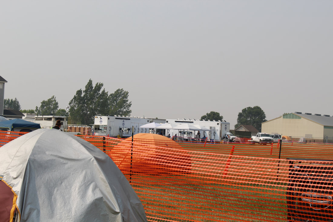 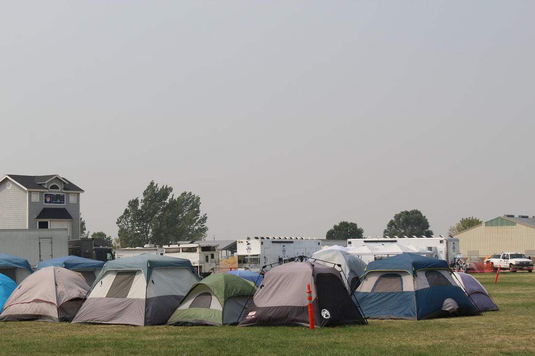 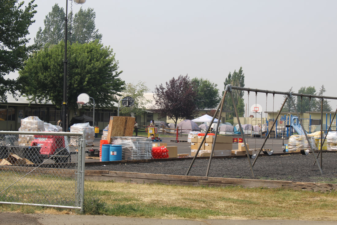 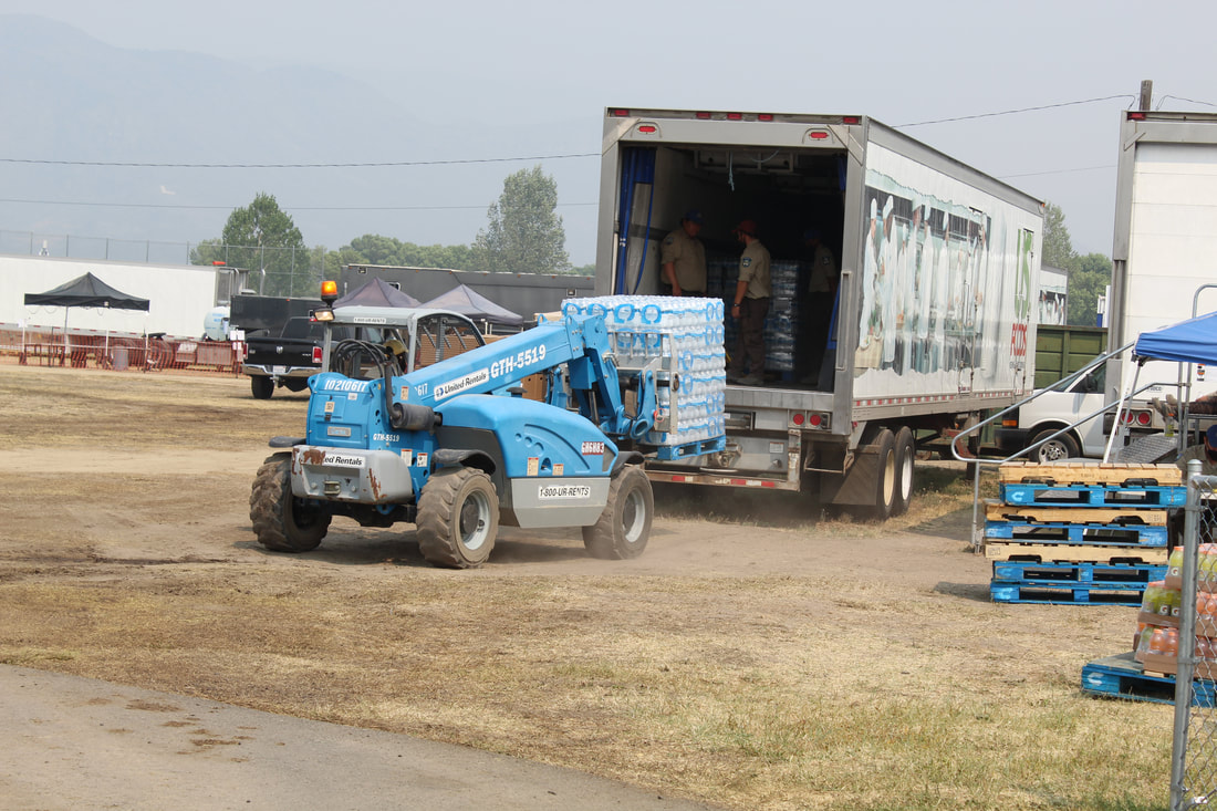 THE SCHOOL BOARD held a special meeting Tuesday concerning distance learning and the school calendar.
superintendent James Berardi talked of spending months and were ready to go face to face which was “not meant to be.” He told of tests, transportation not to fill busses and the fire crews “building a city,” on both Loyalton campuses and now being on the State’s Watch List due to COVID-19 cases, the need to support the effort to move back to distance learning. It approved a calendar suggested by Sierra Plumas Teachers’ Association President Laurie Petterson. Approved was September 3 and 4 would be District days. September 8th would be first day of distant learning. It will remove the Wednesday before Thanksgiving, one of the February days, one day of Easter travel, remove two of the early snow days and extend the year by three days. The Superintendent stressed it was “not my decision or the Board’s decision,” and it’s “out of our hands.” Under Public Comment, Jane Roberti was bothered by a lack of communication and transparency, Elementary School Principal Annie Ceresola told how parents were frustrated how zoom kicks parents off. Heather Fraser suggested hitting Star 6 to unmute. Berardi agreed technology is a huge hindrance and told of 20 hot spots purchased to turn cell phones signals into t spots. As an alternative, they will provide hard packets if needed. He stated we’re doing what the majority of students in California are doing under the Governor’s guidelines. He stressed they will bus hard packets if needed, Heather spoke on the sports program and the social aspect of school and to “give kids some sort of hope to go back.” She told of feeling “disheartened.” James told of the no contact sports in the State but if and when CIF allows it, they will institute it as fast as they can and how they’d tried to get football up and running but are told by the local health department what is allowed. He is planning a move back off the Watch List and maybe football as a Spring sport. North Complex Resources: 5 Type 1 crews, 3 Type 2IA crews, 2 Type 1 helicopters, 1 Type 2 helicopter, 53 engines, 5 bulldozers, 2 water tenders, 719 total personnel. Current Situation on the North Complex: The North Complex consists of multiple lightning caused fires (August 17, 2020) on the Plumas and Lassen National Forests. The Sheep Fire moderated overnight allowing crews to establish new dozer line. The Claremont Fire broke over Highway 70 yesterday near the Massack Rest Area and remained active last night moving along the highway. The Bear Fire grew to 1,078 acres. More details of these fires are covered in separate updates. Of the original 21 fires in the complex, 16 are now 100% contained. The Willard and Fleming burned together with the Sheep. The Iron Fire south of Taylorsville (40 acres) and the Copper Fire (65 acres) north of Greenville are now 100% contained. Crews continue to mop up and reinforce the containment lines on those fires. The Neer, Kessler, Anna, Monitor, Monitor 2, Monitor 3, Paxton, Branch, Little, Loop B, Davis, Davis 2, Evans, and Meyers Fires are all 100% contained and in patrol status. Those fires ranged in size from .1 acres to 8 acres. Weather: RED FLAG WARNING FOR DRY THUNDERSTORMS THROUGH MONDAY EVENING. There is increasing potential for isolated to scattered dry thunderstorms over much of Northern California. Lightning from dry thunderstorms will have the potential to start new fires. Air Quality: Numerous regional fires continue to contribute dense smoke conditions across the region. Smoke impacts to communities are expected to be greatest late in the afternoon towards the evening. For a fire and smoke map, go to https://fire.airnow.gov/ Closures/Evacuations: Highway 70 remains CLOSED between Spring Garden and Quincy La Porte Road. Due to 100 percent containment on the Iron and Copper Fires, evacuation orders and advisories have been lifted for the Greenville and Taylorsville areas. For immediate text notifications about emergency alerts, residents can sign up for the Plumas County’s CodeRed Emergency Alert System on https://www.plumascounty.us/2163/CodeRed-Emergency-Alert-System. Evacuation questions should be directed to Plumas County Sheriff’s Office: (530) 283-6375. Evacuation shelter for the Claremont fire is at the Quincy High School. No small animals are able to be accommodated at the High School. Evacuation shelter for the Sheep Fire is located at the Lassen Community college dormitories. Large animals can be housed at the Lassen County Fairgrounds. Visit CalTrans at quickmap.dot.ca.gov for the latest maps with road closures in your area. COVID-19: California Interagency Incident Management Team 1 has implemented precautionary measures to prevent the spread of COVID-19 in both fire the surrounding communities. North Complex Fires: Claremont Fire – https://inciweb.nwcg.gov/incident/6996/ Bear Fire – https://inciweb.nwcg.gov/incident/7025/ Sheep Fire – https://inciweb.nwcg.gov/incident/6997/ Forest Closures: https://fs.usda.gov/alerts/plumas/alerts-notices ### Today over 14,000 firefighters are on the frontlines of more than two dozen major fires and lightning complexes across California. Last night, firefighters aggressively worked to strengthen containment lines. In anticipation of the upcoming weather patterns, crews continue to perform firing operations to burn away vegetation in an attempt to slow down and stop the spread of the wildfires. Since the lightning siege that started on Saturday, August 15, 2020, there have been nearly 12,000 lightning strikes. During this time-period, there have been more than 615 new wildfires, which have now burned over 1.1 million acres. All current active wildfires, across all jurisdictions, have burned nearly 1.3 million acres across California. The weather forecast for the upcoming days continues to be warm and dry. Remnants of Hurricane Genevieve will bring thunderstorms as early as this morning and continue through Tuesday. A Red Flag Warning has been issued by the National Weather Service for lightning with very little to no rain. The winds will generally be light, however erratic gusty winds of up to 65mph may occur. This dry lightning will likely hamper efforts to contain the current fires and may spark new fires. With extreme fire danger expected this weekend, it is critical that all Californians take steps to prevent sparking a wildfire. To learn more ways to prevent sparking a wildfire visit www.ReadyForWildfire.org. Fires of Interest: **CAL FIRE Incidents** LNU Lightning Complex Fire, Napa County (more info…) Napa County State DPA, SRA, Napa County * 341,243 acres, 17% contained *Hennessey (merged fires) 261,793 acres, 15% contained *Wallbridge 50,069 acres, 0% contained *Meyers 2,345 acres, 0% contained *Estimated 560 structures destroyed *Evacuations in place *CAL FIRE IMT-2 in command SCU Lightning Complex Fire, Contra Costa, Alameda, Santa Clara and Stanislaus Counties (more info…) Contra Costa, Alameda, Santa Clara and Stanislaus Counties * 339,968 acres, 10% contained *20 fires in the complex *Marsh 3,000 acres *Canyon/Reservoir (merged) 285,485 acres *Deer 3,294 acres *Arroyo 189 acres *Evacuations and road closures in place *5 structures destroyed *CA IMT-6 in command CZU August Lightning Fire, San Mateo and Santa Cruz Counties (more info…) San Mateo and Santa Cruz Counties *71,000 acres, 8% contained *Warnell Fire has now merged into CZU Lightning *Evacuations in place *97 structures destroyed *CAL FIRE IMT #3 is in command BTU/TGU Lightning Complex Fire, Butte and Glenn Counties (more info…) Butte, Tehama and Glenn Counties *52,262 acres, 20% contained *Elkhorn 33,000 acres *Ivory 12,500 acres *Potters (5-4) 1,012 acres *CAL FIRE IMT- 4 in command River Fire, Monterey County (more info…) East of Salinas *48,424 acres, 15% contained *16 structures destroyed *Evacuations in place *CAL FIRE IMT Team 1 in command Carmel Fire, Monterey County (more info…) South of Carmel *6,695 acres, 10% contained *32 structures destroyed *Evacuations in place *CAL FIRE IMT 1 Team in command Moc Fire, Tuolumne County (more…) Moccasin • 2,800 acres, brush, 10% contained • Continued structure threat • Evacuations in place Salt Fire, Calaveras County (more info…) Northeast of Copperopolis *1,789 acres, 85% contained Hills Fire, Fresno County (more info…) South of Coalinga *2,121 acres 94% contained Jones Fire, Nevada County (more info…) Northwest of Nevada City *705 acres, 55% contained *Evacuation in place *5 residential structures destroyed **Unified Command Fires** Lake Fire, Los Angeles County (more info…) Southwest of Lake Hughes * 31,089 acres, 52% contained *Continued structure threat *Unified Command USFS and Los Angeles County Fire *CA IMT Team 5 is in command **Federal Incidents** August Complex, Tehama County (more…) Grindstone Canyon, Elk Creek * 160,005 acres 11% contained Dolan Fire, Monterey County (more info…) Ventana Wilderness – Los Padres National Forest *19,278 acres, 10% contained Ranch 2 Fire, Los Angeles County (more info…) San Gabriel Canyon *4,237 acres, 49% contained *Road closures in place *Federal Type 2, in command Apple Fire, Riverside County (more info…) Cherry Valley *33,424 acres, 95% contained North Complex Fire, Plumas County (more info…) Southwest of Susanville - Plumas National Forest *27,701 acres, 5% contained *Evacuations in place * Includes the Claremont Fire *Road and trail closures in effect *CA IMT Team 1 is in command Loyalton, Vegetation Fire, Sierra County (more info…) East of Loyalton – Tahoe National Forest * 47,028 acres, 75% contained Red Salmon Complex – Shasta-Trinity National Forest (more info…) Northeast of Willow Creek, CA *18,960 acres, 39% contained Castle Fire, Tulare County (more…) East of Giant Sequoia National Monument *3,800 acres, brush and timber, 0% contained W-5 Cold Springs, Lassen County (more…) East of Madeline. *22,000 acres, 10% containment Dome, San Bernardino County (more…) Mojave National Preserve *43,273 acres, 95% contained Beach, Inyo County (more…) Inyo National Forest *3,780 acres, 80% contained Blue Jay/Wolf Fire, Mariposa County (more…) Yosemite National Forest *340 acres, 10% contained Hull Fire, Glenn County (more…) North of Lake Pillsbury *2,000 acres Woodward Fire, Marin County (more…) Point Reyes National Seashore *2,689 acres 5% contained **Local Government** Holser, Vegetation Fire, Ventura County/Los Angeles County (more info...) FINAL South of Lake Piru *3,000 acres, 100% contained ### Acres: 11,885 Resources: 15 dozers, 36 engines, 2 hand crews, 2 helicopters, and 12 water tenders. Additional resources are on order, availability remains scarce. Current Situation on the Claremont: Despite firefighters’ efforts to keep the fire from crossing the Highway 70 corridor today, winds and spotting resulted in a breach this afternoon with a 5-acre spot fire near the Massack Rest Area. This necessitated Highway 70 to be CLOSED between Spring Garden and La Porte Road. There was no estimated time of reopening at the time of this release. No structure have been reported lost. The Claremont Fire, now at 11,310 acres, is located south of Quincy, CA and north of the Middle Fork of the Feather River. Current Situation on the Bear: The Bear Fire increased in fire activity this afternoon, but a size update is not available at this time. It was last reported at 575 acres. The Bear is located on the Pacific Crest Trail, 1-mile northwest of Butte Bar Campground and 1.5 southeast of Lookout Rock. It is in very steep and inaccessible terrain. Weather: A new thunderstorm system is expected to bring dry lightning and gusty winds starting Sunday morning. The storm is expected to last several days, elevating fire danger, and has prompted a FIRE WEATHER WATCH for the fire area. Air Quality: Smoke, including thicker particulate matter from active fires across northeast California, will continue to affect the area through Sunday morning. Expect visibility below 3 miles with unhealthy air quality for sensitive groups and those spending a prolonged period of time outdoors. For a fire and smoke map, go to https://fire.airnow.gov/ Closures/Evacuations: Highway 70 is CLOSED between Spring Garden and Quincy La Porte Road. There is an ADVISORY Evacuation Order for East Quincy (south of Lee Road from Radio Hill Road East), Candler Road (from HWY 70 east entrance to Hillside Drive), Greenhorn Ranch, and Spring Garden. Mandatory evacuations remain in effect for East Quincy, south of Highway 70 between Millcreek east to Quincy La Porte Road, as well as Quincy La Porte Road from Highway 70 south to Red Bridge (Middle Fork of the Feather River) An evacuation center for all residents (East Quincy, Greenhorn, Massack and Spring Garden) has been set up at Quincy High School. No small animals are able to be accommodated at the High School. The Red Cross is currently working to assist us in establishing a secondary evacuation center. Road Closure: La Porte Road and Thompson Creek Road remain closed. The Pacific Crest Trail from Onion Valley to Bucks Summit remains closed. For further information on closures go to: https://www.fs.usda.gov/alerts/plumas/alerts-notices For immediate text notifications sign up for the Plumas County’s CodeRed Emergency Alert System on their website at https://www.plumascounty.us/2163/. Evacuation questions should be directed to your County Sheriff's office non-emergency number. Plumas County Sheriff’s Office: (530) 283-6375. COVID-19: California Interagency Incident Management Team 1 has implemented precautionary measures to prevent the spread of COVID-19 in both fire camp and the surrounding communities. ### |