SIERRA COUNTY
DEPARTMENT OF TRANSPORTATION
Bryan Davey
Deputy Director
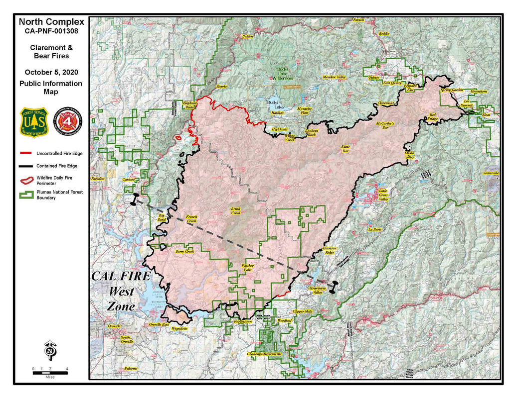
Posted on: October 6, 2020PUBLIC NOTICEA routine water sample taken last week had a positive result for coliform. This is likely the result of some dirt in the water system. Over the weekend we flushed the system and retested on Monday morning. Several of these tests had positive results for total coliform. As a precautionary measure the water system will be chlorinated to eliminate the cause of any additional positive tests. At this time there is no health risk and no need to take any special precautions for water use. It is possible that you may notice a slight odor of chlorine or a slight aftertaste in the water. If you have a hypersensitivity to chlorine you may want to take measures to reduce water use for several days. This is only a temporary situation and should dissipate quickly once the system is completely flushed after chlorination. If you have any questions or need additional information please contact me at (530) 289-3201.
SIERRA COUNTY DEPARTMENT OF TRANSPORTATION Bryan Davey Deputy Director
0 Comments
$6.6 million nationwide campaign runs through November 8 WASHINGTON – U.S. Secretary of Transportation Elaine L. Chao announced the launch today of this year’s Stop. Trains Can’t. public education campaign, which will run through November 8. This national $6.6 million safety campaign will run on radio, digital, and social media, educating drivers not to gamble with their lives at rail grade crossings. The campaign will also target high-risk highway-railway crossings in Alabama, Arizona, California, Georgia, Indiana, Tennessee, and Texas. “So many fatalities at highway-railway crossings are preventable; this campaign aims to raise public awareness and save lives,” said U.S. Secretary of Transportation Elaine L. Chao. The Federal Railroad Administration (FRA) and the National Highway Traffic Safety Administration (NHTSA) manage this campaign. “Evolving technology will continue to help reduce fatalities at our nation’s rail grade crossings, but driver awareness is paramount to bringing down the fatality rate,” said Ronald L. Batory, Administrator of the Federal Railroad Administration. “A train can’t swerve out of the way or stop on a dime,” said NHTSA Deputy Administrator James Owens. “We all have a responsibility to be safe while on the highways, and that means drivers must always look carefully before driving across train tracks and obey any warning signals or lowered crossing gate arms. Trying to beat a train could cost you your life.” Over the past five years, 798 people have died while trying to drive across railroad tracks. In 2019 alone, 126 people were killed and 635 people were injured at railroad crossings. Of those killed, about 75% died after the driver went around lowered crossing gate arms. For social media graphics, video, and more from the campaign, please click here. ### Betty Thatcher of Loyalton has been recognized by the Sierra County Arts Council as a featured artist in our Sierra County Artist Program. Betty creates beautiful watercolors inspired by her love of country living and Sierra County. Betty began her art career at the Loyalton Senior Center in 2009, where Lola Owen was teaching classes. Many artists in Sierra County were mentored by Lola who was an artist and gallery owner originally from Tahoe. Betty found her own style, painting whimsical watercolors that capture the spirit and personality of her subject whether it is the Sierra Valley, historic barns and buildings, old cars, people, or a variety of animals including happy pigs, strutting chickens and graceful antelope. As her friend Kathleen Goicoechea commented recently, “Betty’s watercolors are painterly”. Watercolor is the most immediate and unforgiving of mediums. There are no second chances. Betty has perfected her creative talent, using a variety of techniques that often she has discovered on her own. Betty was instrumental in bringing Barn Quilts to the Sierra Valley. Her art is currently featured at the Lombardi Mercantile in Loyalton and in the hallway in the old pharmacy building in Loyalton. The Lombardi Mercantile features local arts and crafts and provides art and craft workshops through “Creamery Classes”. Contact the Mercantile at 530-993-4331. Email: thatcherb63@gmail.com Facebook: Betty Williams Clark Thatcher. See her on the Sierra County Arts Council Facebook and Instagram pages. #sierracountyartscouncil #loyalton #sierravalley
Sierra County Arts Council is State-Local Partner with the California Arts Council. Information at www.sierracountyartscouncil.org, email: bj@sierracountyartscouncil.org, phone: 530-289-9822 or B.J. @530-862-1241. (Alturas, CA) – It is with great enthusiasm that we introduce to you the newest railroad preservation society in the western states: the Nevada-California-Oregon Railway. As a historical society, we are dedicated to preserving the legacy of the three-foot narrow gauge railway that ran from Reno, Nevada to Lakeview, Oregon and through Sierra Valley to Clio, California. Our focus on this 50-year narrative of the region’s history allows us to go deeper into the records of one of the longest narrow gauge railroads in the country. Headquartered in Alturas, CA, we are surrounded by several of the remaining facilities once built and occupied by the N-C-O Ry. after its move from Reno, NV. in 1917. The administration building, in its unique mission-nuevo architecture, the last remaining employee house, the engine shop where many of the later rolling stock were built, the pump house that supplied water to locomotives and facilities, and the freight depot and passenger depot are all standing as reminders of an earlier time. We look forward to partnering with other organizations and individuals to create a robust online collection of documents, photos, and stories to share. We also are working with private owners to acquire and preserve the remaining rolling stock and equipment to bring the N-C-O Ry. back to life. HOW YOU CAN HELP: If you have any information, documentation or items that may assist in preserving the history of the N-C-O Ry, please contact us at Contact@NCORy.org. We are looking for: newspaper articles, journals, letters, shipping receipts, tickets and passes, photographs, postcards, drawings, track items, depot and railway signage, boxcar or passenger car parts, railroad tools, or a family story told verbally. We seek anything that may help us learn more about this unique part of our region’s railroad history. As the Board of Directors of the newly formed Nevada-California-Oregon Railway, we are excited to get this organization moving forward! A few projects are in the works, and we will be pleased to share with you as we make progress in the coming weeks. So, join us as we dive into the history of the N-C-O Ry. by exploring our website NCORy.org, subscribing to our E-Blasts, and following us at Facebook.com/NCORy.org. Completing the 2020 Census is a matter of minutes and will help bring much needed resources and infrastructure support to Rural California. Take the Census Here The Census 2020 period will continue through the end of the month, which means under reported communities in the Sierra have until October 31st to complete the Census. Less than 50% of Plumas and Sierra counties have completed the Census. Please help us ensure rural California is counted by reminding (or even helping) your friends, neighbors, family, and associates to fill out their Census today! Taking the Census will help your community in rural California thrive by determining what resources are allocated to the region in the event of a wildfire or other natural disaster, where congressional boundaries are drawn, how nonprofits and other community organizations serve the region, and how the area's unique demographics and population size impact the needs of the community. See below for instructions on how to make sure you are counted in the 2020 Census, and please forward to friends, family, and colleagues who need to see this information. Taking the census is quick and easy, and can be done in a matter of minutes. Click here to take the Census online today or call 1-844-330-2020. This morning we met with several agencies at the Incident Command Post to evaluate all of the closures, evacuations and advisories in Plumas County. Effective at 12:00 PM today we will be lifting all road closures and evacuations advisories along La Porte Rd from the Plumas/Yuba County Line north down Quincy La Porte Road to Highway 70.
For Bucks Lake, the mandatory evacuation order will remain in place. After speaking with the IMT and looking at the weather, there are higher winds expected to impact the fire west of Bucks Lake and we need to see what this weather/wind will do to fire activity before we reassess lifting any orders in the Bucks Lake area. For information on any changes to the Highway 70 closure please monitor the CHP - Quincy and Caltrans District 2 Facebook pages. Another reminder, people using Hwy 162 from Butte County to access the MANDATORY closure area of Bucks Lake. Nobody should be accessing Bucks Lake via Hwy 162 at this time. According to Butte County Sheriff "ORO-QUINCY HWY FROM LAKE MADRONE NORTH TO THE BUTTE COUNTY LINE. (Open to residents only)". Please stop bypassing the closure signs and trying to access the Bucks Lake area! You are putting yourself and fire personnel working in the area at risk. PCSO would like to extend a huge thank you to the public for your support and patience during this lengthy incident. Respectfully, Chandler Peay Deputy Sheriff / PIO Plumas County Sheriff's Office TAHOE FOREST HEALTH SYSTEM ORTHOPEDIC PROGRAM RECOGNIZED FOR FRAGILITY FRACTURE PATIENT CARE10/5/2020 By the American Orthopaedic Association (www.tfhd.com) (Tahoe/Truckee, CA) - Tahoe Forest Health System (TFHS) is proud to announce they have received an Own the Bone Star Performer designation for the 2021 year, an achievement reserved for institutions that perform the highest level of fragility fracture and bone health care. Tahoe Forest Health System achieved an exceptional compliance rate on the 10 prevention measures outlined by the American Orthopaedic Association (AOA), including: educating patients on the importance of calcium and vitamin D, physical activity, falls prevention, limiting alcohol intake, and quitting smoking, recommending and initiating bone mineral density testing, discussing pharmacotherapy and treatment (when applicable), and providing written communication to patients and their physicians regarding specific risk factors and treatment recommendations. Through participation in AOA’s Own the Bone program and recognition as an Own the Bone Star Performer, Tahoe Forest Health System has demonstrated a commitment to helping patients understand their risk for future fractures and the steps they can take to prevent them. “We work hard to both educate patients and to keep our patients safe,” says Harry Weis, Chief Executive Officer, TFHS. “We are grateful for the recognition of our exceptional orthopedics team and program and we thank our community for continuing to trust us with their health and well-being.” What can patients do to protect their bones? · Get adequate calcium and vitamin D, either through diet or supplements, if necessary. · Engage in regular weight bearing and muscle strengthening exercise. · Prevent falls around the home and be careful of stairs, railings, clutter, etc. · Avoid smoking and limit alcohol intake to 2-3 drinks per day. Have you or a loved one had a broken bone over age 50? Talk to your health care provider and get a bone density screening to determine if osteoporosis might be the cause and learn additional steps you might need to take to prevent future fractures. For more information about Tahoe Forest Health System’s orthopedic program and treatment options, please contact the Orthopedics & Sports Medicine clinic at (530) 587-7461, or visit www.tahoeorthopedicsandsports.com # # # SIERRA COUNTY – Medicare’s Open Enrollment period begins Oct. 15 and ends Dec. 7. During that period, Medicare recipients may:
To help you understand your options, you can schedule a free one-on-one session with a local state-registered HICAP Medicare counselor. HICAP (the Health Insurance Counseling & Advocacy Program) is administered by the California Department of Aging. Its trained volunteer counselors are available by phone and video-conferencing to answer questions and help seniors and other eligible recipients understand their Medicare rights and benefits. HICAP counselors can provide information about Medicare supplemental insurance (Medigap policies); Medicare Advantage plans; employee and retiree coverage; long-term-care insurance and how to appeal coverage denials. HICAP serves clients in El Dorado, Nevada, Placer, Sacramento, San Joaquin, Sierra, Sutter, Yolo and Yuba counties, regardless of income or age. To schedule a free, one-hour phone or videoconference appointment with a state-registered HICAP Medicare counselor in Sierra County, call(530) 993-4770. Once your appointment is scheduled, you will receive an appointment reminder by phone, email or text prior to your appointment. For more information, go to www.HICAPservices.net. Second Quarter 2020 Projections Show Reduced Overall Fatalities
Trends Toward Risky Driving Behaviors During Public Health Crisis Are Cause for Concern WASHINGTON – The U.S. Department of Transportation’s National Highway Traffic Safety Administration today released a preview of 2019 data from the Fatality Analysis Reporting System and preliminary estimates for the first half of 2020. Alongside the release of the 2019 preview data and 2020 first-half fatality projections, the agency issued two companion reports, Special Report: Examination of the Traffic Safety Environment During the Second Quarter of 2020 and Drug and Alcohol Prevalence in Seriously and Fatally Injured Road Users Before and During the COVID-19 Public Health Emergency. Traffic deaths decreased nationwide during 2019 as compared to 2018. There were 36,096 fatalities in motor vehicle traffic crashes in 2019. This represents a decrease of 739 (down 2%) from the reported 36,835 fatalities in 2018, even though vehicle miles traveled increased by nearly 1%. As a result, the fatality rate for 2019 was 1.10 fatalities per 100 million VMT – the lowest rate since 2014, down from 1.14 fatalities per 100 million VMT in 2018. Fatalities decreased in most major traffic safety categories in 2019:
NHTSA also released preliminary fatality estimates for the first half of 2020. The second quarter of 2020, during the height of the COVID-19 public health emergency, showed a continued decline in overall traffic fatalities. The FARS data indicate that an estimated 8,870 people died in motor vehicle traffic crashes in the second quarter of 2020, a decrease of about 3.3% compared to the second quarter of 2019, which translates into 302 fewer fatalities as compared to the same period in 2019. At the same time, at the height of the COVID-19 public health emergency, the total traffic volume decreased by more than 16% in the first six months of 2020. Because traffic volumes decreased more significantly than did the number of fatal crashes, the traffic fatality rate per 100 million VMT is projected to increase to 1.25 in the first half of 2020, up from 1.06 in the same period in 2019. “Road safety is always our top priority, and while we are encouraged by today’s reports showing a continued decline in total fatalities in 2019 and into the first half of 2020, we are concerned by the trend since April showing an increased fatality rate,” said NHTSA Deputy Administrator James Owens. “Now, more than ever, we should be watching ourselves for safe driving practices and encouraging others to do the same. It’s irresponsible and illegal to drive under the influence of drugs or alcohol, taking risks not only with one’s own life, but with the lives of others.” To assist stakeholders in evaluating the trend and identifying countermeasures, NHTSA researchers compiled data from a wide variety of sources to produce a special report also issued today. The study suggests that during the height of the national public health emergency and associated lockdowns, driving patterns and behaviors changed significantly, and that drivers who remained on the roads engaged in more risky behavior, including speeding, failing to wear seat belts, and driving under the influence of drugs or alcohol. Traffic data indicates that average speeds increased during the second quarter, and examples of extreme speeds became more common, while the evidence suggests that fewer people involved in crashes used their seat belts. NHTSA also released a study of seriously or fatally injured road users at five participating trauma centers during this time, finding that between mid-March and mid-July almost two-thirds of drivers tested positive for at least one active drug, including alcohol, marijuana, or opioids. In particular, the number of such drivers testing positive for opioids nearly doubled after mid-March, as compared to the previous six months, while marijuana use increased by about 50%. Last week, NHTSA announced a series of workshops with stakeholders starting today to bring together State and local officials and safety advocates to discuss data and develop countermeasures to address these serious safety concerns. Over the summer, NHTSA launched a new campaign to remind motorists to drive safely and follow traffic safety laws. NHTSA’s high-visibility enforcement campaign to combat impaired driving ran through the Labor Day weekend and will be repeated later this year in time for the holidays. ### Motorists Should Plan for Guided, Round-Robin Escorts Through the Construction Zone
FARAD – Caltrans is set to resume rock excavation with blasting work on Interstate 80 near Farad next week with 30-minute delays anticipated for east- and westbound motorists. For the safety of the traveling public, Caltrans and Q&D Construction will require temporary traffic holds of 30 minutes or less for rock blasting on Tuesday, Oct. 6 and Wednesday, Oct. 7 between 9 a.m. and 3 p.m. The California Highway Patrol will be escorting westbound traffic from the Nevada state line and eastbound traffic from Hirschdale Road through the construction zone in a round-robin fashion. Blasting is required to reduce large boulders to a more manageable size for slope stabilization work along the highly traveled interstate. The work is part of a $12.9 million slope stabilization project that will restore the Farad Ditch by extending the collection area. The project is anticipated to be completed in summer 2021. Caltrans reminds motorists to Be Work Zone Alert and slow in construction zones for the safety of travelers and crews performing these improvements. Weather or unexpected events may delay or prolong the work. The department will issue construction updates on Twitter @CaltransDist3 and on Facebook at CaltransDistrict3.For real-time traffic, click on Caltrans’ QuickMap quickmap.dot.ca.gov/ or download the QuickMap app from the App Store or Google Play. ### SUSANVILLE, Calif., – The Lassen National Forest (LNF) is issuing Forest Order 06-20-13 that opens its developed campgrounds for camping. This Order supersedes Order Number 06-20-11 and will be in effect from October 3, 2020, through November 30, 2020. Portable lanterns and camp stoves using gas, jellied petroleum, or pressurized liquid fuel that maybe now be used on our developed campgrounds. There is a ban in place on all campfires, outdoor BBQs, and smoking on the LNF.
The following developed campgrounds are open on the LNF. Almanor Ranger District Campgrounds Almanor North Campground (open until October 26), Battle Creek Campground (open until November 1), Butte Meadows Campground (open until November 1), Domingo Springs Campground (open until October 26), Echo Lake Campground (open until October 26), Legacy Campground (open until November 1). Potato Patch Campground (open until November 1), and Silver Bowl Campground (open until October 26). Eagle Lake Ranger District Campgrounds Butte Creek Campground (open year-round), Bogard Campground (open year-round), Crater Lake Campground (open year-round), Eagle Campground (open year-round), and Merrill Campground (open until November 1). Hat Creek Ranger District Campgrounds Cave Campground (open until November 30), and Hat Creek Campground (open until October 12). ”Dispersed camping is not allowed on the LNF,” said Deb Bumpus. Forest Supervisor. “There are several developed campgrounds available the rest of the season to enjoy.” The following persons are exempt from this Order:
USDA is an equal opportunity provider, employer, and lender. Caring for the land and serving people As nearly 17,000 firefighters continue to work towards containment on 23 major wildfires across the state, Red Flag conditions continue throughout the day in parts of California. Yesterday, crews also responded to 29 new wildfires, bringing full containment to all. Since the beginning of the year, there have been over 8,200 wildfires that have burned well over 3.9 million acres in California. Currently, over 53,000 residents are evacuated across the state. The total number of fatalities statewide increased again yesterday to a total of 31 after another victim of the LNU Lightning Complex succumb to their injuries. To date, nearly 8,000 structures have been destroyed. A Red Flag Warning continues through today into Saturday for the North and South Bay, Southern Mendocino County, Western Lake County and Western Monterey County for locally gusty winds and low humidity. High temperatures also persist, adding to the critical fire weather danger. A slight cooling trend is not expected until later in the weekend or early next week. California historically experiences some of the most devastating wildfires in the months of September and October. Do not let your guard down! To learn more ways on how to prevent sparking a wildfire, visit www.ReadyForWildfire.org. Fires of Interest: **CAL FIRE Incidents** Zogg Fire, Shasta County (more info…) Southwest of Redding *56,018 acres, 46% contained *4 Fatalities *Evacuation orders in place *CAL FIRE Team 2 in command Glass Fire, Napa and Sonoma County (more info…) 4 miles east of Calistoga *60,148 acres, 6% contained *Evacuation orders in effect and additional evacuations in progress *CAL FIRE Team 3 in command Butte/Tehama/Glenn (BTU/TGU) Lightning Complex, multiple Counties (more info…) Butte, Tehama, and Glenn Counties *19,609 acres, 97% contained *14 structures destroyed *While no growth is expected, fire suppression repair work is ongoing. **Unified Command Incidents** North Complex, Plumas County (more info…) Northeast of Oroville to southwest of Quincy (Plumas National Forest) *316,685 acres, 79% contained *15 fatalities *2,342 structures destroyed *Evacuations in place *Includes the Bear and Claremont Fire *CAL FIRE Team 4 is in unified command with US Forest Service IMT Team 4, Butte County Sheriff’s Office and California State Parks Martindale Fire, Los Angeles County (more info…) Bouquet Canyon, Northeast of Santa Clarita *230 acres, 95% contained *Structures threatened *Evacuation orders remain in place *Unified Command USFS and Los Angeles County FD Creek Fire, Fresno County (more info…) Northeast of Shaver Lake (Sierra National Forest) *311,703 acres, 45% contained *Evacuations in place *Heavy tree mortality in the area *852 structures destroyed *CAL FIRE Incident Management Team 1 in unified command with USFS Great Basin Team 1 SQF Complex, Tulare County (more info…) 3 miles east of Giant Sequoia National Monument *153,226 acres, 61% contained *Evacuations in place *232 structures destroyed *CAL FIRE Incident Management Team 6 in unified command with USFS Team 2 **Coordinated Command Incidents** August Complex, multiple Counties (more info…) Colusa, Glenn, Lake, Mendocino, Tehama and Trinity Counties Elk Creek and Stonyford area (Mendocino National Forest) *970,563 acres, 51% contained *South Zone 490,748 acres, 70% contained *North Zone 356,487 acres, 32% contained *West Zone 123,328 acres, 55% contained *1 fatality *159 structures destroyed *Includes multiple fires including the Elkhorn, Hopkins, Willow, Vinegar, and Doe fires *Pacific North West Team 2 in command of the South Zone *Alaska Incident Management Team 1 is in command of the North Zone *CAL FIRE Incident Management Team 5 is in unified command on the West Zone **Federal Incidents** Snow Fire, Riverside County (more info…) Snow Creek Rd, west of Palm Springs *6,254 acres, 95% contained El Dorado Fire, San Bernardino County (more info…) West of Oak Glen (San Bernardino National Forest) *22,744 acres, 93% contained *1 fatality *10 structures destroyed *California Interagency Incident Management Team 13 in command Slater Fire, Siskiyou County (more info…) 5 miles North of Happy Camp (Klamath National Forest) *154,445 acres, 50% contained *2 fatalities *Evacuation orders in place Devil Fire, Siskiyou County (more info…) 5 miles north of Upper Devil’s Peak (Klamath National Forest) *8,506 acres, 20% contained Bobcat Fire, Los Angeles County (more info…) North of Duarte (Angeles National Forest) *114,901 acres, 79% containment *Evacuations in place Dolan Fire, Monterey County (more info…) Hwy 1, 10 miles south of Big Sur (Los Padres National Forest) *124,924 acres, 90% contained *Structures threatened *California Interagency Incident Command Team 15 in command Bullfrog Fire, Fresno County (more info…) SE of Bullfrog Lake (Sierra National Forest) *1,185 acres, 50% contained Fork Fire, El Dorado County, (more info…) 15 miles northeast of Pollock Pines (El Dorado National Forest) *1,667 acres, 70% contained Apple Fire, Riverside County (more info…) Oak Glen/Cherry Valley (San Bernardino National Forest) *33,424 acres, 95% contained Red Salmon Complex – Humboldt County (more info…) 14 miles northeast of Willow Creek (Shasta-Trinity National Forest) *129,191 acres, 31% contained Blue Jay Fire, Mariposa County (more info…) Yosemite National Park Wilderness *5,335 acres, 50% contained Wolf Fire, Tuolumne County (more info…) Yosemite National Park Wilderness *1,092 acres, 60% contained Woodward Fire, Marin County (more info…) FINAL 3 miles southwest of Olema (Point Reyes National Seashore) *4,929 acres, 100% contained Slink Fire, Mono County (more info…) 2 miles west of Coleville (Humboldt-Toiyabe National Forest) *26,759 acres, 86% contained Moraine, Tulare County (more info…) Sequoia and Kings Canyon National Parks Wilderness *668 acres, 70% contained Rattlesnake, Tulare County (more info…) Sequoia and Kings Canyon National Parks Wilderness *4,471 acres, 30% contained **Extended Attack** Copper Fire, Amador County (more info…) 4 miles west of Rancho Murieta *48 acres, 70% contained. Top 20 Wildfire Records
SACRAMENTO, Calif. – California’s Water Year 2020 has come to a close and while Northern California was mostly dry, parts of Southern California experienced above average precipitation. The water year ended below average and further demonstrated the impact of climate change on the state’s water supply.
“California is experiencing the impacts of climate change with devastating wildfires, record temperatures, variability in precipitation, and a smaller snowpack,” said DWR Director Karla Nemeth. “We must continue to invest in our infrastructure to prepare the state to cope with more extreme weather for the state’s needs today and in the future.” For Water Year 2020, a lack of precipitation resulted in a snowpack of just 50 percent of average on April 1, as measured by the California Cooperative Snow Survey Program, making it the 10th smallest snowpack in California since 1950. California’s reservoirs received just a third of the water runoff from precipitation and snowmelt that they did during the same time period a year ago. The impacts of dry conditions were tempered, however, because of good reservoir storage from a wet 2019. Statewide reservoir storage through the end of September 2020 is projected to be 93 percent of average or 21.5 million-acre feet. DWR’s annual water year recap, “Water Year 2020: Summary Information” highlights additional key details of the water year which runs from October 1 to September 30. Focused on tangible actions to help build a climate-resilient water system, the state recently finalized the California Water Resilience Portfolio outlining almost 150 actions to better prepare our state for long-term water resilience. The continued water year variability is also a reminder to all Californians that we need to be prepared for dry periods. For more information visit: California’s Most Significant Droughts: Comparing Historical and Recent Conditions. ### Sierra Brooks Firewise First-Annual Neighborhood Green Waste Clean-up- Photos by Victoria Fisher10/1/2020 On September 26, 2020 the residents of Sierra Brooks had the opportunity to participate in a community-wide green waste clean-up event. This annual event took place as one of the first stages in becoming a Firewise Community offering a chance for home owners to get involved in increasing defensible space around their homes. As a result, an estimated 319 yards of green waste was removed from Sierra Brooks, with the Loyalton Cogen reporting 22,460 pounds of that amount being delivered directly to their facility. The Sierra Brooks Firewise Community Volunteer Group would like to thank the following people and businesses as this day would not have been possible without them; Sierra Valley Enterprises, LLC (Jeff Holland, Kirk Furlong-Wentworth, Jim Turner and Bonnie Richards), Intermountain Disposal, Inc., Sierra County Road Department (Tim Beals, Rob Moore and crew), Sierra County Fire Safe Council, Inc., Loyalton Volunteer Fire Department (Shawn Heywood and crew), Sierra Brooks Home Owners Association, Boy Scouts Troop #60 (Derrick Koch and kids), members of the Loyalton Football Team and FFA, Supervisor Dryden and local community members. We thank you for your time and amazing hard work and cannot express enough how grateful we are to have had this turnout. With appreciation, The Sierra Brooks Firewise Community Volunteer Group Plumas-Sierra CattleWomen, Wow what a fantastic day it was! On Friday Sept. 25th Plumas Sierra CattleWomen had pizza delivered to Nervino Airport Beckwourth, Ca. to the Helibase Crews, First Responders, and Care Flight Crews. Along with a batch of homemade cookies. The Helibase Crews, which are from all over the United States have been here for over a month, helping to fight our destructive California Wildfires. Three cattlewomen, Flinda France, Marjorie Logan, and Jan Tew were privileged enough to serve these brave and heroic men and women. A large poster card was signed by PSCW and many of the businesses in Portola Ca. and presented to them. We were treated to a tour of the helicopters and given a brief summary of what each one is used for. From the smallest to the biggest each have a specialty. We've never meant a more Thankful, Grateful, and Gracious Group of People. Thank You again for you Tireless and Relentless Hours spent helping our State!! Sincerely, Plumas Sierra Cattlewomen Submitted by Flinda France The California Department of Fish and Wildlife (CDFW) has launched a new blog on its website called the "Bear Naked Truth" to provide Lake Tahoe-area residents and visitors with accurate, up-to-date information on Tahoe Basin bear activity along with CDFW guidance and best practices for coexisting with black bears. "It's been a busy summer in Lake Tahoe with regard to bear activity and conflicts," said Jordan Traverso, CDFW's deputy director of communications. "One of the things we've learned from this is that there is a tremendous hunger among residents for reliable, truthful and practical information about bear activity and CDFW's policies, management and response to that activity. We expect this new blog to help address that information void." Tahoe Basin residents can find the Bear Naked Truth blog at the following address: www.wildlife.ca.gov/conservation/mammals/black-bear/blog. There is an option to subscribe and receive blog updates by e-mail. The blog features CDFW contact information for residents dealing with bear issues, links to CDFW's bear policies and best practices for living and recreating safely in bear country. "Our responsibilities regarding bears in the Tahoe Basin, and all of California for that matter, are ensuring a healthy black bear population, public safety and education," Traverso said. "This blog will help advance those goals. Bears can become public safety threats if they become comfortable around people and dependent on human food and garbage. Keeping these bears wild for their own well-being and the well-being of those who live and vacation in Lake Tahoe is in everybody's best interest." # # # SACRAMENTO, Calif. – To help support the California Highway Patrol’s (CHP) yearlong effort to improve pedestrian and bicycle safety, the Department was awarded the California Pedestrian and Bicyclist Enforcement and Education Project VIII grant. The CHP will use the grant funds to conduct enhanced-enforcement patrols and public awareness campaigns through September 30, 2021. “Whether traveling by motor vehicle, bicycle, or on foot, we all share the road. Bicycle and pedestrian safety is everyone’s responsibility,” CHP Commissioner Warren Stanley said. “This grant provides us additional resources to focus on the safety of pedestrians and bicyclists, our most vulnerable roadway users.” Pedestrian and bicycle fatalities accounted for nearly 33 percent of all traffic-related deaths in California in 2018. The CHP reminds motorists to always scan each intersection for potential foot and bicycle traffic and to yield the right-of-way to pedestrians whether in marked or unmarked crosswalks. On October 7 – the National Center for Safe Routes to School’s “Walk and Bike to School Day” – the CHP will focus on locations with high numbers of pedestrian and bicyclist crashes. Officers in plain clothes will work with uniformed officers to monitor crosswalks for motorists and pedestrians who fail to yield the right-of-way or who take unsafe or illegal actions. The CHP will also use the grant funding to educate the public on safe and courteous traffic behavior through public presentations and safety publications, and to provide bicycle and pedestrian safety equipment for distribution including bicycle helmets and reflective gear. Funding for this program was provided by the California Office of Traffic Safety through a grant from the National Highway Traffic Safety Administration. The mission of the CHP is to provide the highest level of Safety, Service, and Security. ### - campfires and dispersed camping prohibited - fire closures- QUINCY, Calif. – Fire Restrictions on the Plumas National Forest (PNF) are continuing due to unprecedented and historic fire conditions throughout the state. A ban on all campfires, outdoor BBQ's, and smoking is in place. Portable lanterns and camp stoves using gas, jellied petroleum, or pressurized liquid fuel may be now be used in four open, developed campgrounds on the PNF. Areas near active and recent fires (North Complex (Bear/Claremont and Sheep) and Walker) remain closed. The entire Feather River Ranger District (west side of the PNF), including all national forest system land, roads, trails, campgrounds, lakes, etc., remains closed. No activities, including hunting and woodcutting, are allowed on the Feather River Ranger District currently. The Bucks Lake area is under continuing evacuation orders per the Plumas County Sheriff. Camping is available on a first-come/first-serve basis at specific developed campgrounds; dispersed camping is not allowed. Frenchman Lake: Boat launches include Frenchman (wet launch) and Lunker Point (dry launch). All campgrounds are now closed for the season. Lakes Basin: Gold Lake and Lakes Basin Family Campgrounds are open until October 15, 2020 and then closed for the season. Goose and Haven closed for the season on September 30. Lake Davis: Grasshopper Flat and Lightning Tree Campgrounds will be open until October 31, 2020 and then closed for the season. Dry boat launch is available at Lightning Tree while wet boat launch opportunities include Camp Five, Honker Cove and Mallard Cove. All other campgrounds are closed for the season. Antelope Lake: The Lost Cove Boat Launch is open at Antelope Lake (wet launch) with no fees and services. All campgrounds are closed for the season. Woodcutting is allowed with a permit in open areas and if daily fire restrictions allow (1-800-847-7766). Note: The free personal woodcutting permit program has been extended through December 31, 2020 and current permits slated to expire September 30 will be honored until December 31, 2020. Additional Forest information is available at www.Facebook.com/usfsplumas and http://www.fs.usda.gov/plumas. ### Twitter: @usfsplumas USDA is an equal opportunity provider, employer, and lender. Full containment was announced on two of the largest lightning complexes that began in August. The LNU Complex and the SCU Complex are 100% contained as of this morning. As crews prepare for another round of Red Flag Warnings, over 17,000 firefighters remain on the lines of 24 major wildfires across the state. Crews across the State also responded to 23 new wildfires yesterday, bringing full containment to all. Since the beginning of the year, there have been over 8,100 wildfires that have burned well over 3.9 million acres in California. Currently, over 96,000 residents are evacuated across the state. Sadly, yesterday it was announced that another victim was found on the Zogg Fire, bringing the total number of fatalities statewide to 30. Also, over 7,500 structures have been destroyed. A Red Flag Warning is in effect beginning this afternoon and continuing through much of Friday for the North and South Bay, Central Mendocino County, Western Monterey County and most of the Los Padres National Forest for gusty winds and low humidity. High temperatures also persist, adding to the critical fire weather danger. A slight cooling trend is not expected to until later in the weekend or early next week. California historically experiences some of the most devastating wildfires in the months of September and October. Do not let your guard down! To learn more ways on how to prevent sparking a wildfire, visit www.ReadyForWildfire.org Fires of Interest: **CAL FIRE Incidents** Zogg Fire, Shasta County (more info…) Southwest of Redding *55,303 acres, 26% contained *4 Fatalities *Evacuation orders in place *146 structures destroyed *CAL FIRE Team 2 in command Glass Fire, Napa and Sonoma County (more info…) 4 miles east of Calistoga *56,781cres, 5% contained *Evacuation orders in effect and additional evacuations in progress *CAL FIRE Team 3 in command today LNU Lightning Complex, multiple North Bay counties (more info…) **FINAL** Napa, Lake, Sonoma, Colusa, Solano, and Yolo Counties *363,220 acres, 100% contained SCU Lightning Complex, multiple Easy Bay counties (more info…) **FINAL** Contra Costa, Alameda, Santa Clara San Joaquin, Merced, and Stanislaus Counties *396,624 acres, 100% contained Butte/Tehama/Glenn (BTU/TGU) Lightning Complex, multiple Counties (more info…) Butte, Tehama, and Glenn Counties *19,609 acres, 97% contained *14 structures destroyed *While no growth is expected, fire suppression repair work is ongoing. **Unified Command Incidents** North Complex, Plumas County (more info…) Northeast of Oroville to southwest of Quincy (Plumas National Forest) *316,149 acres, 79% contained *15 fatalities *2,342 structures destroyed *Evacuations in place *Includes the Bear and Claremont Fire *CAL FIRE Team 4 is in unified command with US Forest Service IMT Team 4, Butte County Sheriff’s Office and California State Parks Martindale Fire, Los Angeles County (more info…) Bouquet Canyon, Northeast of Santa Clarita *230 acres, 85% contained *Structures threatened *Evacuation orders remain in place *Unified Command USFS and Los Angeles County FD Creek Fire, Fresno County (more info…) Northeast of Shaver Lake (Sierra National Forest) *309,033 acres, 44% contained *Evacuations in place *Heavy tree mortality in the area *855 structures destroyed *CAL FIRE Incident Management Team 1 in unified command with USFS Great Basin Team 1 SQF Complex, Tulare County (more info…) 3 miles east of Giant Sequoia National Monument *151,436 acres, 61% contained *Evacuations in place *232 structures destroyed *CAL FIRE Incident Management Team 6 in unified command with USFS Team 2 **Coordinated Command Incidents** August Complex, multiple Counties (more info…) Colusa, Glenn, Lake, Mendocino, Tehama and Trinity Counties Elk Creek and Stonyford area (Mendocino National Forest) *955,513 acres, 51% contained *South Zone 489,380 acres, 70% contained *North Zone 346,156 acres, 35% contained *West Zone 119,977 acres, 65% contained *1 fatality *86 structures destroyed *Includes multiple fires including the Elkhorn, Hopkins, Willow, Vinegar, and Doe fires *Pacific North West Team 2 in command of the South Zone *Alaska Incident Management Team 1 is in command of the North Zone *CAL FIRE Incident Management Team 5 is in unified command on the West Zone **Federal Incidents** Snow Fire, Riverside County (more info…) Snow Creek Rd, west of Palm Springs *6,254 acres, 95% contained El Dorado Fire, San Bernardino County (more info…) West of Oak Glen (San Bernardino National Forest) *22,744 acres, 93% contained *1 fatality *10 structures destroyed *California Interagency Incident Management Team 13 in command Slater Fire, Siskiyou County (more info…) 5 miles North of Happy Camp (Klamath National Forest) *154,507 acres, 48% contained *2 fatalities *Evacuation orders in place Devil Fire, Siskiyou County (more info…) 5 miles north of Upper Devil’s Peak (Klamath National Forest) *8,410 acres, 20% contained Bobcat Fire, Los Angeles County (more info…) North of Duarte (Angeles National Forest) *114,901 acres, 75% containment *Evacuations in place Dolan Fire, Monterey County (more info…) Hwy 1, 10 miles south of Big Sur (Los Padres National Forest) *124,924 acres, 90% contained *Structures threatened *California Interagency Incident Command Team 15 in command Bullfrog Fire, Fresno County (more info…) SE of Bullfrog Lake (Sierra National Forest) *1,185 acres, 50% contained Fork Fire, El Dorado County, (more info…) 15 miles northeast of Pollock Pines (El Dorado National Forest) *1,667 acres, 70% contained Apple Fire, Riverside County (more info…) Oak Glen/Cherry Valley (San Bernardino National Forest) *33,424 acres, 95% contained Red Salmon Complex – Humboldt County (more info…) 14 miles northeast of Willow Creek (Shasta-Trinity National Forest) *124,464 acres, 31% contained Blue Jay Fire, Mariposa County (more info…) Yosemite National Park Wilderness *4,673 acres, 50% contained Wolf Fire, Tuolumne County (more info…) Yosemite National Park Wilderness *1,092 acres, 35% contained Woodward Fire, Marin County (more info…) 3 miles southwest of Olema (Point Reyes National Seashore) *4,929 acres, 98% contained Slink Fire, Mono County (more info…) 2 miles west of Coleville (Humboldt-Toiyabe National Forest) *26,759 acres, 86% contained Moraine, Tulare County (more info…) Sequoia and Kings Canyon National Parks Wilderness *668 acres, 70% contained Rattlesnake, Tulare County (more info…) Sequoia and Kings Canyon National Parks Wilderness *4,070 acres, 0% contained **Extended Attack** Candy Fire, Riverside County (more info…) **FINAL** Candy Lane, Southeast of Lake Mathews Reservoir *227 acres, 100% contained Copper Fire, Amador County (more info…) **NEW** 4 miles west of Rancho Murieta *48 acres, 50% contained Top 20 Wildfire Records
|
CONTACT US:Sierra Booster Newspaper
PO Box 8 Loyalton, CA 96118 Phone: 530-993-4379 Fax: 844-272-8583 Email: jbuck@psln.com Website Privacy Policy |
©Copyright Sierra Booster - Sierra County News - Editorial
Website by Chamber Nation
|